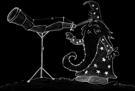
Sketching astronomical objects
This site is dedicated to my astronomical drawings.
Sketching deep-sky objects helps to improve observing skills.
Over time - my technique should become better...
- You are here:
-
Home

- StarMapStudio
Self made
Star maps
StarMapStudio
Sunday, June 15, 2008
StarMapStudio is a free software that prints star atlases. I added a new menu for StarMapStudio on this site, that should help me to keep you informed.
Just click on one one of the menus under StarMapStudio to read the whole story. ;)
And yes, I uploaded a first star map made with StarMapStudio.
Just download it here (ca. 1600 KB). The map shows the Cassiopeia constellation with different limiting magnitudes. It includes an object list as well. You will need Adobe's Acrobat Reader in order to open it.
Thursday, May 1, 2008
Do you know this? You want to find a faint deep-sky object. You are about to do some star hopping, you have prepared a map and your telescope is positioned at the starting point of the journey. Then you look through your finding telescope and you see stars, a lot of stars... Then you try to compare the picture with the star field on your map... and now... you are confused. If you only had a map that would show a similar star field as the one that's in your eye piece.
What you need is a map that matches the limiting magnitude of your finding aids under the current sky condition. The limiting magnitude (LM) is the faintest star that visually can be seen through an instrument. Of course, the number will vary in respect to sky quality and the human eye's condition.
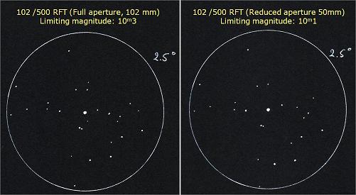
Determining LM for my equipment
My finding aids are a 8 x 50 finder scope and a 102/500 RFT (Rich Field Refractor). The best way to find out the LM is to sketch a known star field under normal conditions and compair the results with a detailed star map (I used HNSKY with the GSC 1.2 star catalogue for that purpose.) I sketched the Polaris star field. Sky conditions were moderate: fst=5m5 and seeing=II.
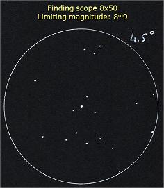
I decided to do an experiment with the RFT: I reduced its aperture to 50 millimeters in order to see what the difference would be. I was a bit surprised that there only was a difference of a few tenths of a magnitude, but in Milky Way regions that small difference will dim a lot of stars making the star hopper's life easier...
Producing the right maps
It's obvious, that I will need at least two maps. I will do intensive field testing in the next couple of months with new maps having LM of 9 and 10 while varying the scaling. After testing is done, I can start to create my new star atlas.
Friday, February 1, 2008
Looking for the perfect star atlas
During the past few years I tried out several atlases just to find out that the perfect atlas doesn't exist. Either the scaling is too small or too large or the format doesn't satisfy. The map's limiting magnitude rarely matches my finding equipment or the object selection doesn't fit my needs.
I also tried free planetarium software such as HNSKY or Cartes Du Ciel . The main problem here is that I have to create a map for each observation which is a time consuming task while these programs are not specialized in producing printed output.
Taki's Star Atlas and astromist
I finally sticked with Taki's 8.5 Magnitude Star Atlas. It covers the complete sky, it offers a good scaling, it comes in a handy A4-Format and it's free! After I added constellation figures using green ink (under red light, constellations appear grey at night.), these maps are very useful in the field.
For planets and ephemeris calculations, I use Astromist. This is a fine astronomical software for handhelds. It has an observer log allowing me to save my astronomical drawings in the database - so they are available in the field in case I want to review an older sketch. I just love it!
StarMapStudio
But for me, Taki's maps still have some disadvantages: the 8.5 limiting magnitude is too little and some constellations are not positioned the way I like - e.g. the Cassiopeia "W" is split and printed on the pages: 13,14, 36 and 37. So I started to search for a method to create my own PDF maps.
I soon found myself digging into the exciting theory of cartography. I found an old software called StarMapStudio, I wrote some database conversion routines for it and asked the author for his future plans. He expressed his wish to discontinue the project and he transferred all StarMapStudio copyrights to me.
That is how my newest astronomical project (and this blog) started. The project will consist of 3 main tasks:
- Re-publish StarMapStudio 1.3 with a recent database.
- Create my own PDF atlas and share it with the community.
- Re-develop StarMapStudio 2.0 from scratch.
I will post any news about the project in this blog. Have fun and CS!